Herd Wear Distribution center
Unique Map of the Mississippi River - Reproduction
Unique Map of the Mississippi River - Reproduction
Couldn't load pickup availability
What a great and unique frameable, educational, displayable piece. The whole of the Great River ... source to Gulf of Mexico .... and original done in the late 1800's. Meticulously re-copied on a very special finished paper by Jones Press, Amarillo, Texas ... just for us.
Why would anyone want such a map? Well, let me explain. In the "Book Hoard" that Ronson Page and I are digging through (ok, only Ronson is "digging"), he found this very interesting book, published in 1887. The original of this map was a "center-fold" in the book.
***** This is another of the bibliographical historical rabbit holes into which I have fallen (written that way to avoid dangling a participle over the said "rabbit hole". What I mean is until Ronson showed me the map... and the book, I had no interest in the Mississippi other than having had a very pleasant day fishing it's banks right above Lock and Dam #6 below Trempealeau, Wisconsin. Heck of a day .... but that is another story!*****
The book is titled "Down the Great River: Embracing an Account of the Discovery of the True Source of the Mississippi". The river is, of course, the Mississippi River. And great is was and remains. The map is found in this book, folded into 6ths. Unfolded it measures right at 38" by 4".
The book was first published in 1887, with additional publishing dates of 1888,1889, 1891, 1892 and 1893 ... at the very least. This map is in that 1887 first edition.
Our book is in poor shape, as you can see by the pictures. But the map is so detailed and as best we can tell very accurate. Thus, we had some great reprographic prints made. Mark Jones; Jones Press in Amarillo does many fine art prints for people all over the US. Mark just winces when I come in, as it usually, as with this, involved something "out of the ordinary. He has made copies of old bison cookbooks, old magazine articles on bison, many out-ot-print or hand typed volumes that I wanted to make available at affordable pricing.
Mark is just a great and extremely talented printer when it comes to modern reproduction of the rare and valuable.
Mark just loved this project. He found a special paper; was able to print it in one strip, unlike the original which had to be taped together. But Mark also captured the pinkish tint of that tape from the original, as well as the slight inaccuracy of the alignment - he completely captured the glory of this old map.
Now back to the question, Would you like a copy of this beautiful piece of American History? Thanks to Ronson and Mark, you can. At least 22 of you can (Ronson and I each claimed one of the 24 I had printed.
Another part of the flipping rabbit hole: I found a historic map company that has an apparent "original" map from the adventurer ... Capt. Glazier about the same river. They want $4,284.00 for it. Here's the link: https:map of mississippi river.
Now it is not the same map, and it is apparently dated about 3 years (1884) before our map (1887) .... but which would you like?
These are not folded ...as the original is. If you want it folded to match the original just tell me before I ship. For framing I thought they would be best just left flat. As such, we will ship them gently rolled so they can be framed flat if preferred.
Ok ... enough about bunnies, maps and old books for the moment.
But wait!!! those other map guys have this added to their site ... and it is inciteful
About this Item - the 4K map
"Good. Some wear on old fold lines. A few minor verso repairs at fold intersections. Minor spotting. Size 21.5 x 33.75 Inches. This is an impressive c. 1887 Willard Glazier map of northern central Minnesota in the vicinity of Leech Lake and Lake Itasca. The map records Willard W. Glazier's claims to have discovered the 'true' source of the Mississippi River at Elk Lake, which he attempts to rename 'Lake Glazier'. Glazier's claims contain an element of truth, and this map has merit, despite his 'discoveries' being universally derided by the geographical establishment due largely to distaste for his bombastic and abrasive personal character. A Closer Look Coverage is loosely centered on Cass Lake but embraces Leech Lake, Lake Winnibigoshish, Lake Bemidji, and Lake Itasca - thus tracing Glazier's exploratory route in red. Although Henry Schoolcraft (1793 - 1864) identified Lake Itasca as the river's primary source in 1832, there remained general consideration that there may be a further source. Joseph Nicolette, for example, traveling with John Fremont in the 1830s, further identified nearby Nicolette Creek as the 'start' of the great river. Glazier is here attempting something similar. Elk / Glazier Lake is situated just south of Lake Itasca. It is one of Lake Itasca's many feeder lakes, but geologists have long since determined that neither Elk Lake nor any of the other minor feeder lakes are large enough to constitute a 'source' for the Mississippi. An enchanting illustration of the lake as a woodland paradise appears in the upper right. Glazier's voyage, with his brother George and friend Barrett Channing Paine, began in Brainerd, Minnesota. They intended to follow the Mississippi from 'Source to Sea'. The trio followed the government road to Leech Lake, from which, on July 17, 1881, they set off in a canoe, following various lakes, streams, and the De Soto River westward to Lake Itasca, where they set up camp on an island on July 21. From there, the group traveled south, where, after some exploration, Glazier determined that Elk Lake (Glazier) was the Mississippi's source. His return took him on a wide arc north of Lake Itasca along the Mississippi to Lake Bemidji, Cass Lake, and Winnibegoshish. There, on July 28-29, the team rested at a Chippewa Village before navigating down the Mississippi to the Gulf of Mexico, which they reached on November 15, 1881. To support his claims, and perhaps intentionally mirroring Schoolcraft's Ojibwe guide O-zaw-wan-dib (fl. 1797 - 1832), Glazier invokes his own 'Indian Guide' Che-No-Wa-Ge-Sic, of whom he writes, … a council was held, and my object stated to them. They were requested to delineate maps of the country, and to furnish an interpreter, guides and canoes. Che-no-wa-ge-sic said: 'My brother, the country you are going to visit is my hunting ground. I have hunted there many years, and planted corn on the shores of Lake Itasca. My father, now an old man, remembers the first white chief who came to look for the source of the Great River. But, my brother, no white man has yet seen the head of the Father of Waters. I will myself furnish the maps you have called for, and will guide you onward. Glazier promoted his discovery through two books, Down the Great River; Embracing an Account of the Discovery of the True Source of the Mississippi (1887) and Headwaters of the Mississippi comprising biographical sketches of early and recent explorers of the great river, and a full account of the discovery and location of its true source in a lake beyond Itasca (1894). Glazier's claims were nonetheless universally derided and rejected by the geographical establishment, who, led by statesman James Heaton Baker (1829 - 1913), pronounced him stupid, pretentious, shameful, bombastic, a fraud, a liar, a plagiarist, a 'tourist', a 'literary thief', a 'falsifier of history', a 'quack explorer', a 'charlatan adventurer', and 'a merry fellow on a jolly outing'. But was he? Certainly, Glazier was pretentious."
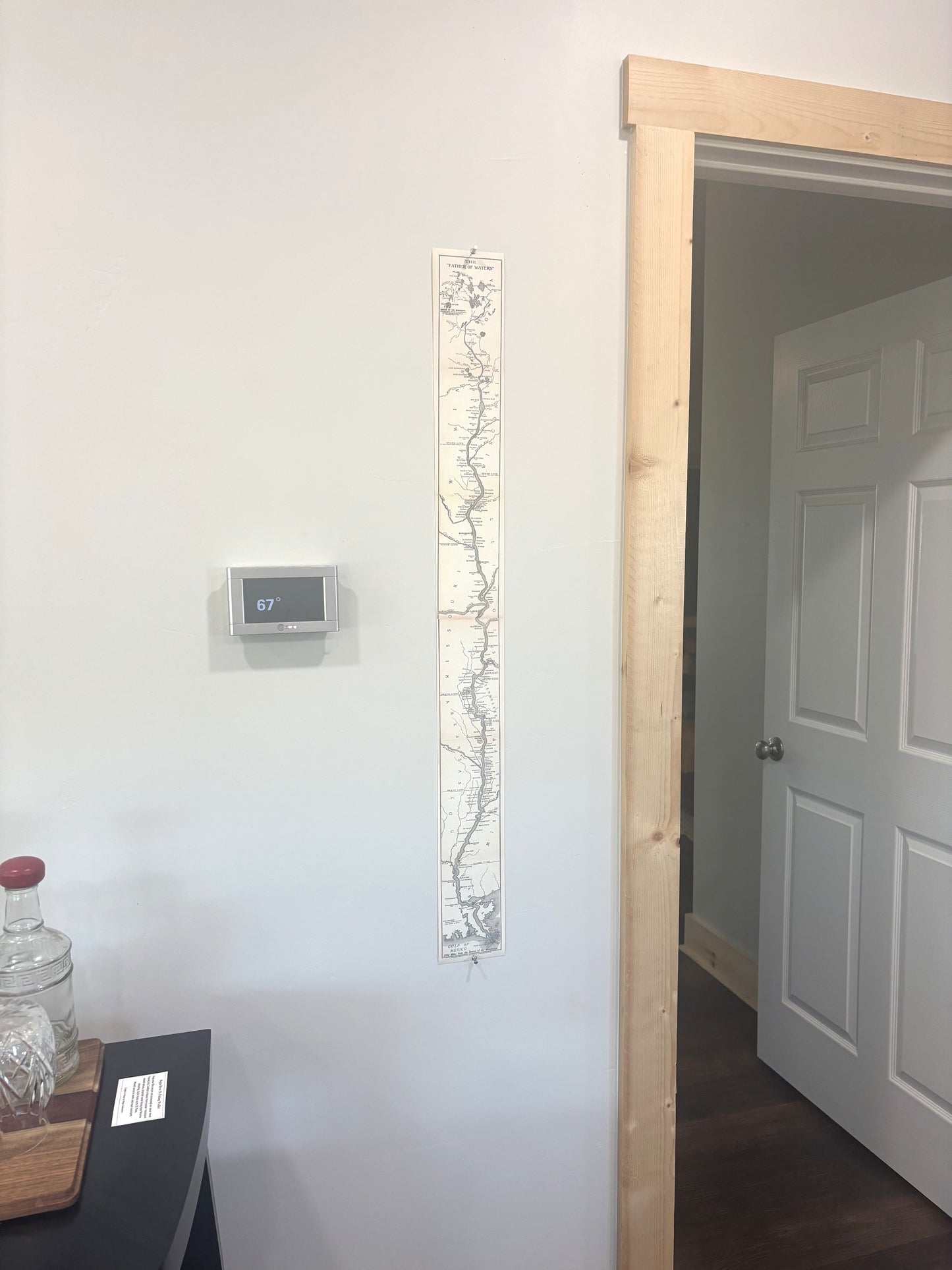
So, a very very long story (I wonder how may folk will ever get this far down) about this curiosity. That's my wall and doorway with the map pinned up. I plan to keep it there. Have had several visitors already spend time studying it. Maybe I am nutz ... but history, visuals, works of folks long gone and bringing them out of the dark is, to me, a passion and a pleasure. Now, go buy a copy of this beautiful strip and start (or continue) your own "lifestyle".
Cecil
Share